28 Sep La Palma eruption update 28th September 2021: Lava reaches the sea at 11pm local time
La Palma eruption update 28th september 2021: Lava reaches the sea at 11pm local time
Daily summary
The lava flow began the day approximately 1000 m from the coast, although it advanced quickly throughout the day due to the large volume of fluid lava being emitted from the effusive vent on the northwest sector of the cone. The lava flow crossed to the south of Todoque mountain and reached the sea at 11:00 pm local time after cascading down the cliffs at Playa de Los Guirres. Due to the clouds of vapour being produced by the contact of the lava with the sea, which could contain high concentrations of gases such as hydrogen chloride (HCl), the confinement order in Tazacorte remains in place. Throughout the day, there were also issues with suspended particles in the air, both directly from the volcano and from the burning of plastic and other noxious materials in greenhouses and agricultural buildings by the lava flows. This problem was exacerbated by a low temperature inversion at 600 m preventing the dispersal of these particles in the evening. This led to the exceedance of the PM10 particle air quality threshold level (50 μg/m3) in Los Llanos de Aridane.
Strong strombolian activity continues too with pulses of increased and decreased intensity, and the scientific committee commented that the expulsion of magma from the inner layers of the volcano during the reactivation on the evening of the 27th in part causes more fluid flows. The ash plume height exceeds 4000 m, and the SO2 emissions are greatly increased due to the reactivation of activity, estimated at 16,757 tons per day. Deformation however continues to show a long-term trend of stability at all stations. The increased earthquake activity in the same location as the initial swarm which began on the 11th September, which began on the 27th, continues. In total, 15 earthquakes were recorded, peaking at 3.3 mbLg.
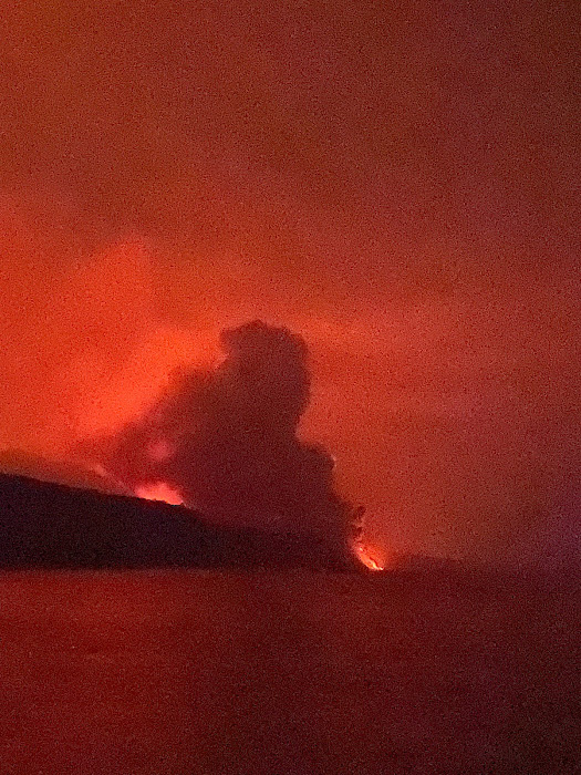
The moment the lava flow reached the sea for the first time, as seen from the port of Tazacorte. Image credit: Rosie Rice, Cambridge University and GeoTenerife
Sources: Government of the Canary Islands, PEVOLCA, Involcan, IGN, DSN, Cabildo La Palma, 112 Canarias, Tolouse VAAC
Lava flows

Earthquakes

Exclusion zone map
Exclusion zones shown here have been approximated from press releases from the Cabildo de La Palma and will not be exact, nor claim to be official maps of the exclusion zones. For official information, please contact the Cabildo de La Palma.

Official social media
To see our full social media archive, visit our open data section or click here.
News articles
- Canary Islands Government – Govt. already mobilized 30 million euros for those affected – here
- El País – How does the eruption in La Palma compare with a supervolcano? – here
- Daily Mirror – La Palma volcano eruption: fears of explosion and toxic gases as lava nears sea – here
To see our full news archive, visit our open data section or click here.
Found a broken web link? We have archived all of our news articles on the WayBack Machine. You can view the pages by 1. pasting the broken link into WayBack Machine and clicking ‘Browse History’ 2. clicking on the latest capture date and then 3. clicking ‘view capture’. Please let us know of any broken web links by contacting us at enquiries@geotenerife.com.
Eruption footage
News and Interviews
Witness Testimonies
Interactive Lava Flow Map
Notes: Use the button in the top right to open the map into full screen mode. Use the legend icon in the top left to see the legend and further information about the map. Click on individual days to see an outline of the lava flows on that day.
Interactive Earthquake Map
click here to enlarge
Notes: The size of the points represents the size of the earthquake, and the colour represents the depth. The map will also only show a certain number of points at once. For ease of use, we recommend you uncheck all dates and the satellite basemap from the legend in the top right, and inspect the earthquakes one day at a time.
Sorry, the comment form is closed at this time.