13 Oct La Palma eruption update 13th October 2021: La Laguna at risk from lava flows
La Palma eruption update 13th october 2021: La Laguna at risk from lava flows
Daily summary
The lava flows to the north of the flow field that prompted the evacuation of La Laguna on the 12th continue to advance, but in an uneven fashion. The furthest north branch of these flows, which was the one of main concern, is losing power and is advancing only slowly. However, the southern of these flows is currently the most active stream, and advances at approximately 50 m per hour. The current affected area of the lava flows is 640 hectares, 28 more than the previous day, and the maximum width of the lava flow field is 1,770 m. However, it was also stressed by PEVOLCA that the eruption is currently affecting only 8% of the island including areas affected by significant ashfall, and that the area covered by lava flows is still <1% of the land area of the island. Regarding eruptive activity, Strombolian activity is still seen from multiple vents within the main cone, and a reactivation of a more effusive vent on the SE flank of the main cone has been confirmed. Pulses of phreatomagmatic activity can also be seen.
For other eruption parameters, volcanic tremor increased throughout the day, although deformation continues to show no patterns in the closest stations to the eruption/ Earthquake activity was similar to the previous day and was concentrated at 10-15 km depth with some deeper (20-40 km) earthquakes. 71 events were recorded, peaking at 4.4 mbLg. The ash and gas plume reached 3000 m, and the SO2 emissions from the volcano remain relatively high at 17,774 tons per day, although this is an underestimate. Meteorological conditions remain unfavourable for ashfall on the south and eastern parts of the island, including the airport. However, both SO2 and PM10 concentrations remained below threshold values at all stations throughout the day.
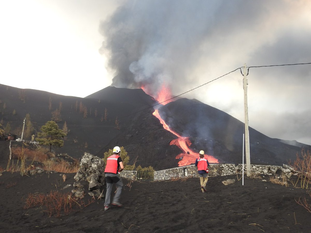
Volcanologists observe the eruption and the effusive focus which is generating the lava flows. Slight overflows of this channel can be seen due to an increase in effusion rate. Image credit: IGN Spain
Sources: Government of the Canary Islands, PEVOLCA, Involcan, IGN, DSN, Cabildo La Palma, 112 Canarias, Tolouse VAAC, Copernicus EMS
Lava flows

Earthquakes

Exclusion zone map
Exclusion zones shown here have been approximated from press releases from the Cabildo de La Palma and will not be exact, nor claim to be official maps of the exclusion zones. For official information, please contact the Cabildo de La Palma.

Official social media
To see our full social media archive, visit our open data section or click here.
News articles
- Daily Express – La Palma volcano: ash to reach Tenerife as homes EXPLODE in lava stream – here
- ITV– Cement factory fire – here
To see our full news archive, visit our open data section or click here.
Found a broken web link? We have archived all of our news articles on the WayBack Machine. You can view the pages by 1. pasting the broken link into WayBack Machine and clicking ‘Browse History’ 2. clicking on the latest capture date and then 3. clicking ‘view capture’. Please let us know of any broken web links by contacting us at enquiries@geotenerife.com.
Eruption footage
News and Interviews
Witness Testimonies
Interactive Lava Flow Map
Notes: Use the button in the top right to open the map into full screen mode. Use the legend icon in the top left to see the legend and further information about the map. Click on individual days to see an outline of the lava flows on that day.
Interactive Earthquake Map
click here to enlarge
Notes: The size of the points represents the size of the earthquake, and the colour represents the depth. The map will also only show a certain number of points at once. For ease of use, we recommend you uncheck all dates and the satellite basemap from the legend in the top right, and inspect the earthquakes one day at a time.
Sorry, the comment form is closed at this time.