18 Oct La Palma eruption update 18th october 2021: New advisories to the population due to poor air quality
La Palma eruption update 18th october 2021: New advisories to the population due to poor air quality
Daily summary
The eruption continues as in the previous days, with a Strombolian mechanism with a predominant effusive phase and a weaker explosive phase. More explosive activity continues to be concentrated in multiple vents within the main cone, and the effusive outlet is seen as a stepped lava channel that runs down the northern flank. The ash emission vent on the SE flank which reactivated on the 16th October continues intermittently. The active lava flow to the south of La Laguna Mountain, closest to the coast, has slowed to 2 m per hour and is currently 160 m from the coast. Elsewhere, advance of the flow front located just above La Laguna has largely stalled for the moment, although the flows continue to widen and thicken. Between 2pm-9pm local time, it was advised in El Paso that the population stay indoors due to unfavourable PM10 concentrations. This was due to the influence of the Saharan air mass, the ash from the volcano, and also the persistence of a low thermal inversion, which is expected to persist until the 22nd October. However, ash dispersion was more favourable than previous days with respect to the operation of La Palma airport.
SO2 concentrations remained below threshold levels throughout the day at all stations. PM10 concentrations remained elevated in all stations due to the presence of the Saharan air mass and also the eruption in the stations in the Aridane Valley, with the daily threshold (50 μg/m3) being exceeded in all stations on the island. Earthquake activity remained similar to previous days and contained both intermediate (10-15 km) and deep (>20 km) earthquakes. 90 events were recorded, peaking at 4.3 mbLg. Deformation remains stable at stations closest to the eruption. The ash and gas plume reached 4000 m, and the SO2 emissions from the volcano were within ranges seen in previous days, at 9,938 tons per day, although this is an underestimate.
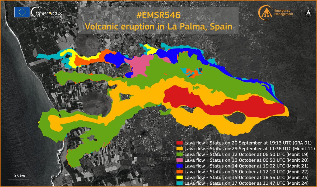
A satellite image showing the progress in the lava flows in the last few days. The progress of the flows to the north of the flow field can clearly be seen. Image credit: Copernicus EMS
Sources: Government of the Canary Islands, PEVOLCA, Involcan, IGN, DSN, Cabildo La Palma, 112 Canarias, Tolouse VAAC, Copernicus EMS
Lava flows

Earthquakes

Exclusion zone map
Exclusion zones shown here have been approximated from press releases from the Cabildo de La Palma and will not be exact, nor claim to be official maps of the exclusion zones. For official information, please contact the Cabildo de La Palma.

Official social media
To see our full social media archive, visit our open data section or click here.
News articles
- Manchester Evening News – Tui cancels flights to La Palma – here
- Inews – Dogs trapped between lava – here
- El País – Drone company to save dogs – here
To see our full news archive, visit our open data section or click here.
Found a broken web link? We have archived all of our news articles on the WayBack Machine. You can view the pages by 1. pasting the broken link into WayBack Machine and clicking ‘Browse History’ 2. clicking on the latest capture date and then 3. clicking ‘view capture’. Please let us know of any broken web links by contacting us at enquiries@geotenerife.com.
Eruption footage
News and Interviews
Witness Testimonies
Interactive Lava Flow Map
Notes: Use the button in the top right to open the map into full screen mode. Use the legend icon in the top left to see the legend and further information about the map. Click on individual days to see an outline of the lava flows on that day.
Interactive Earthquake Map
click here to enlarge
Notes: The size of the points represents the size of the earthquake, and the colour represents the depth. The map will also only show a certain number of points at once. For ease of use, we recommend you uncheck all dates and the satellite basemap from the legend in the top right, and inspect the earthquakes one day at a time.
Sorry, the comment form is closed at this time.