20 Sep La Palma eruption update 20th September 2021: Multiple vents are active
La Palma eruption update 20th september 2021: Multiple vents are active
Daily summary
The new eruption continues with strombolian activity and lava flows being produced from 4 vents along an eruptive fissure, although a principal cone has been formed. The opening of new vents cannot be ruled out, with the final active vent opening at 7:56 pm local time and showing a more effusive character. The lava flows have reached halfway to the sea, although the flow fronts have slowed markedly relative to their initial velocity. Latest estimates give a velocity of 200 metres per hour, and they are expected to reach the town of Todoque within the next couple of days. However, it is uncertain when the flows will reach the sea, although the maritime authorities have extended the oceanic exclusion zone to two nautical miles, for security as well as safety reasons. The exclusion zone has also been extended to include Tacande in the municipality of El Paso as a new eruptive vent 900 metres from the main one has opened, forcing the evacuation of more people, moving the total number of evacuees to approximately 5,500. As well as people, a priority of the authorities is to transfer livestock out of the path of the eruption, including 400 goats in addition to pigs and cattle so far.
The first measurements from the eruption are emerging; the lava flow fronts are 10-12m high, with surface temperatures of up to 1113°C, and the gas plume reaches up to 3000 m high. The SO2 emissions contained in this plume is estimated to be between 8,000-10,600 tons per day. Earthquake size and number has decreased since the onset of the eruption, although a large continuous volcanic tremor signal has also been measured during this time. Furthermore, at 9:32 pm local time, a 3.8 mbLg earthquake was felt throughout the area surrounding the eruption, and PEVOLCA reminds more felt earthquakes should be expected. Deformation also continues to be registered, and in the station closest to the eruption cumulative deformation has reached 20cm. PEVOLCA has stated that some of its priorities, after ensuring the safety and security of the population, is to create a plan for maintaining the supply of irrigation water should pipes be damaged, and to assess the current material damage from the lava flows.
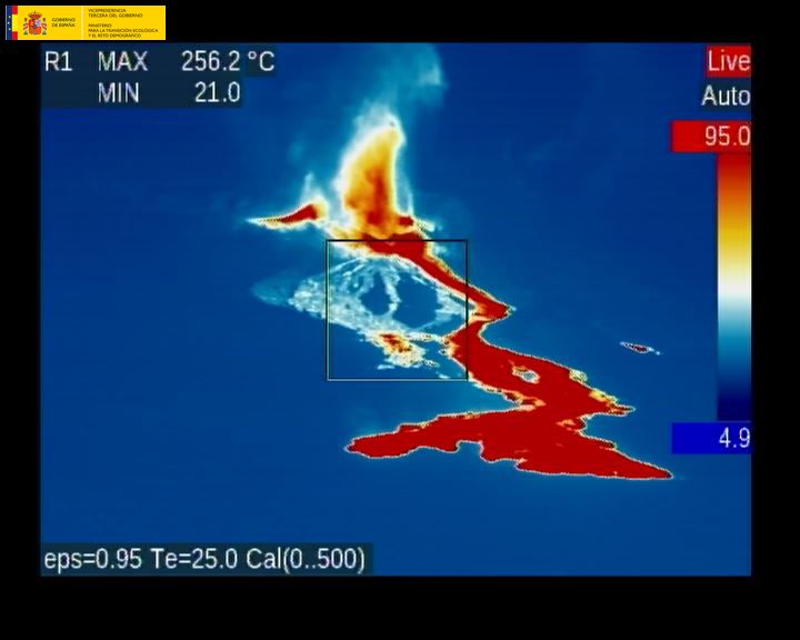
A thermal image of the erupting fissure on the 20th September. Image credit: Government of Spain
Sources: Government of the Canary Islands, PEVOLCA, Involcan, IGN, DSN, Cabildo La Palma, 112 Canarias, Tolouse VAAC
Earthquakes

Exclusion zone map
Exclusion zones shown here have been approximated from press releases from the Cabildo de La Palma and will not be exact, nor claim to be official maps of the exclusion zones. For official information, please contact the Cabildo de La Palma.

Official social media
To see our full social media archive, visit our open data section or click here.
News articles
- El País – Start of the eruption and key questions – here
- The Sun – Talks about British tourists and advice to people wanting to visit the island – here
- EuroNews – Asking about volcano-climate links – here
To see our full news archive, visit our open data section or click here.
Found a broken web link? We have archived all of our news articles on the WayBack Machine. You can view the pages by 1. pasting the broken link into WayBack Machine and clicking ‘Browse History’ 2. clicking on the latest capture date and then 3. clicking ‘view capture’. Please let us know of any broken web links by contacting us at enquiries@geotenerife.com.
Eruption footage
News and Interviews
Witness Testimonies
Interactive Lava Flow Map
Notes: Use the button in the top right to open the map into full screen mode. Use the legend icon in the top left to see the legend and further information about the map. Click on individual days to see an outline of the lava flows on that day.
Interactive Earthquake Map
click here to enlarge
Notes: The size of the points represents the size of the earthquake, and the colour represents the depth. The map will also only show a certain number of points at once. For ease of use, we recommend you uncheck all dates and the satellite basemap from the legend in the top right, and inspect the earthquakes one day at a time.
Sorry, the comment form is closed at this time.