19 Sep La Palma update 19th September 2021: Fissure eruption begins near Las Manchas
La Palma eruption – 19th September 2021
Daily summary
At 15:12 local time, a basaltic fissure eruption began, with the coordinates of the first emission point being 28º36’N, 17º52’W. The eruption has shown phreatomagmatic pulses, especially during the first few hours, characterised by ash-and-steam-rich plumes, which reached heights of 1500-3000 m, although predominantly shows a typical strombolian mechanism. Initial estimates indicate the SO2 emissions from the activity could be between 6,000-9,000 tons per day. Up to seven vents opened up along two 100 m long fissures, orientated parallel to each other along a roughly NS axis. Lava flows from the eruption travelled west towards the coast and have begun to affect properties. Prior to the start of the eruption, a volcanic tremor signal was identified across all seismic stations, and deformation reached a cumulative vertical inflation of 19 cm. The rate of deformation prior to the eruption starting was raised relative to previous days.
The volcano traffic light system was moved to red with the commencement of the eruption but remained at yellow up until that point. In the early hours of Sunday morning, the seismicity reached its maximum since the start of the swarm, which prompted the pre-emptive evacuation of people with reduced mobility from the villages of Las Manchas de Abajo, Jedey, San Nicolás, El Paraíso, El Charco, La Bombilla, El Remo and Puerto Naos. When the eruption began, the immediate evacuation of around 5000 people in nearby towns was ordered, and an exclusion zone of 2 km around the emission centres and a 2 km maritime exclusion zone have been set up. The emission centres have opened up in an unpopulated area, and so far there have been no reported human casualties from the eruption.
The eruption began in a forested area with explosions and a large ash plume. The start was captured by local TV stations. Image credit: Televisión Canaria
In accordance with the ongoing eruption and red traffic light, PEVOLCA has issued the following advice to the affected population:
“Recommendations include closing all exterior windows and doors, lowering blinds, and shutting off water, gas, and electricity supplies.
Carry in a backpack your documentation and medicines for daily use, mobile phone and its charger, battery-powered radio, flashlight, clothes for about three days. Only use telephones for what is strictly necessary
Go to the established meeting points and if you have to go to a shelter, go to the affiliation points.
The red traffic light also provides indications to protect against falling ash. Do not go near the volcano or the lava flows for any reason.
In this sense, they must remain in their homes until they have settled, unless there is danger of the roof collapsing.
Avoid going out and if you do, cover your nose and mouth with a mask to avoid inhaling the ashes directly. Protect your eyes with goggles, wear glasses instead of contact lenses, or place a damp cloth over your mouth. Avoid exercising outdoors.
When ash is falling, close doors, windows and all ventilation in the house (fireplaces, heating, air conditioners, etc.). Remove accumulated ash from flat roofs and rain gutters and keep water tanks and cisterns covered.
Ash must be prevented from coming into contact with food. Wash fruits and vegetables well and do not eat food outdoors.
The accumulated ash must be collected in plastic bags, deposited in containers and avoid throwing it into the public sewer.
While the phenomenon lasts, avoid driving. If you have to, use extreme caution and do not exceed 40 km / h.
Volcanic ash consists of very fine fragments that can cause injury to the respiratory tract, eyes and open wounds, as well as irritation to the skin.
Keep vehicle engines off. Driving can kick up ash, engines can clog, and vehicles can break down.
In the case of feeling an earthquake inside a house, take cover under a door frame or a solid piece of furniture, such as a table, and stand away from windows. Do not use the elevator. If you have to leave your house, disconnect water, electricity and gas.
If you are outside, stay away from tall buildings, utility poles, billboards, etc. and so you are close to the sea, stay away from the shore.
Remember that 1-1-2 is a telephone number of the Canary Islands Government only for emergencies, if you want some kind of general information about the situation you should call 012 or find out through the media.”
Sources: Government of the Canary Islands, PEVOLCA, Involcan, IGN, DSN, Cabildo La Palma, 112 Canarias, Tolouse VAAC
Lava flows

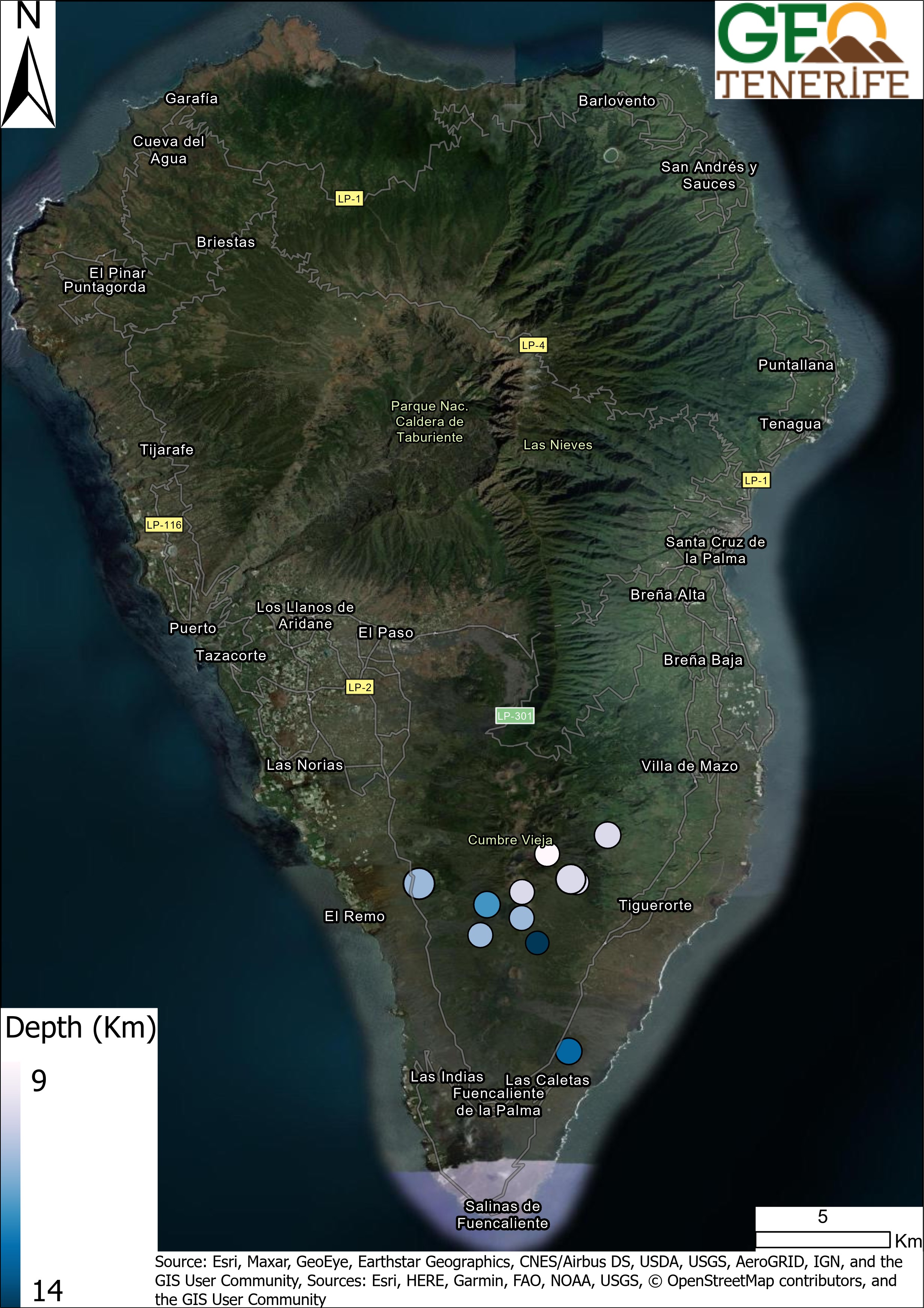
Earthquakes

Exclusion zone map
Exclusion zones shown here have been approximated from press releases from the Cabildo de La Palma and will not be exact, nor claim to be official maps of the exclusion zones. For official information, please contact the Cabildo de La Palma.

Official social media
To see our full social media archive, visit our open data section or click here.
News articles
- Daily Mail – Eruption start – lots of close up images – here
- EuroWeekly News – M4.2 eq on the morning of the 19th – here
- Guardian – Start of the eruption – here
- Independent – Earthquake swarm continuing – here
To see our full news archive, visit our open data section or click here.
Found a broken web link? We have archived all of our news articles on the WayBack Machine. You can view the pages by 1. pasting the broken link into WayBack Machine and clicking ‘Browse History’ 2. clicking on the latest capture date and then 3. clicking ‘view capture’. Please let us know of any broken web links by contacting us at enquiries@geotenerife.com.
Eruption Footage
News and Interviews
Witness Testimonies
Interactive Lava Flow Map
Notes: Use the button in the top right to open the map into full screen mode. Use the legend icon in the top left to see the legend and further information about the map. Click on individual days to see an outline of the lava flows on that day.
Interactive Earthquake Map
click here to enlarge
Notes: The size of the points represents the size of the earthquake, and the colour represents the depth. The map will also only show a certain number of points at once. For ease of use, we recommend you uncheck all dates and the satellite basemap from the legend in the top right, and inspect the earthquakes one day at a time.
Sorry, the comment form is closed at this time.