24 Sep La Palma eruption update 24th september 2021: Increase in eruption intensity seen
La Palma eruption update 24th september 2021: Increase in eruption intensity seen
Daily summary
An increase in explosive activity throughout the day, to the most energetic levels seen since the eruption began, has prompted the evacuation of a further 160 people to the northwest of the volcano, in Tajuya, Tacande de Abajo and those not already evacuated in Tacande de Arriba. The decision was made because of the increased risk of volcanic materials and pressure waves reaching and causing damage in areas outside of the current exclusion zone. In particular, this related to the opening of two new effusive vents as well as a fracture in the NW flank of the main cone, which could destabilise the cone and increase the risk of a sector collapse. The two new effusive vents emit fluid lava flows, that travel faster than previous flows but flow over the top of previous flows. In total, the number of evacuees has now reached 6,000. Latest estimates of damage indicate up to 400 buildings affected by the lava flows.
With the increase in explosive activity, volcanic tremor and SO2 emissions also increased throughout the day, with the latter estimated at >28,000 tons per day. However, air quality with respect to SO2 concentrations in nearby population centres has remained at a ‘good’ level across the surveillance network. Deformation also remains stable across the network, with no patterns of inflation or deflation seen. Earthquake activity remains at a low level, with only 2 earthquakes recorded, peaking at 2.7 mbLg. However, it is worth noting that since the start of the eruption and commencement of constant volcanic tremor, small magnitude (<2.0) earthquakes cannot be recorded and located due to the noise from the volcanic tremor.
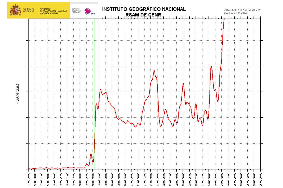
An IGN chart of volcanic tremor showing the increase in volcanic tremor in the last 24 hours. The green vertical line denotes the beginning of the eruption. Image credit: IGN Spain
Sources: Government of the Canary Islands, PEVOLCA, Involcan, IGN, DSN, Cabildo La Palma, 112 Canarias, Tolouse VAAC
Lava flows

Earthquakes

Exclusion zone map
Exclusion zones shown here have been approximated from press releases from the Cabildo de La Palma and will not be exact, nor claim to be official maps of the exclusion zones. For official information, please contact the Cabildo de La Palma.

Official social media
To see our full social media archive, visit our open data section or click here.
News articles
- USA Today – Fact check of Mega Tsunami and Nick Knowles Tweet – here
- Smithsonian Magazine – La Palma Island Volcanic Eruption Sends Lava Flowing to Residential Buildings – here
To see our full news archive, visit our open data section or click here.
Found a broken web link? We have archived all of our news articles on the WayBack Machine. You can view the pages by 1. pasting the broken link into WayBack Machine and clicking ‘Browse History’ 2. clicking on the latest capture date and then 3. clicking ‘view capture’. Please let us know of any broken web links by contacting us at enquiries@geotenerife.com.
Eruption footage
News and Interviews
Witness Testimonies
Interactive Lava Flow Map
Notes: Use the button in the top right to open the map into full screen mode. Use the legend icon in the top left to see the legend and further information about the map. Click on individual days to see an outline of the lava flows on that day.
Interactive Earthquake Map
click here to enlarge
Notes: The size of the points represents the size of the earthquake, and the colour represents the depth. The map will also only show a certain number of points at once. For ease of use, we recommend you uncheck all dates and the satellite basemap from the legend in the top right, and inspect the earthquakes one day at a time.
Sorry, the comment form is closed at this time.