04 Oct La Palma eruption update 4th october 2021: Lava largely follows existing channels
La Palma eruption update 4th october 2021: Lava largely follows existing channels
Daily summary
In the first official assessment of the classification of the eruption based on its size, the authorities have announced that the eruption is a Volcanic Explosivity Index (VEI) 2 eruption. This classification is based solely on the cumulative amount of material emitted by the volcano so far, and as such the VEI may increase as the eruption continues for longer. Several active strombolian vents are still observed in the main cone, as well as two vents on the NW sector of the flank of the main cone, one of which was the site of the partial collapse observed on the evening of the 3rd. The two effusive vents further away from the main vent that opened on the 1st October show less activity than previous days. The fumarole field on the flanks of the main cone is still observed, although is relatively weakened. The active lava flows largely continue to cover ground covered by earlier flows aside from breakouts further away from the cone, and the presence of lava tubes have also been confirmed which allows the transport of more fluid lava. The affected area has increased to 413 hectares, and the maximum width of the flow field is now 1,250 m.
The meteorological conditions remain favourable in terms of air quality, and this is reflected in SO2 and PM10 concentrations. Low SO2 levels are seen across all stations except Los Llanose de Aridane where sporadic peaks are seen, and PM10 threshold levels have not been exceeded in any of the stations. Regarding deformation, the distal stations still show a slight downward trend, although vertical stability is now seen in the proximal stations. Earthquake activity continues to be concentrated near where the precursory seismic swarm began on the 11th September, but with a relatively high number of events. 98 earthquakes were recorded, peaking at 3.7 mbLg. The ash plume height was, 4500 m, and the SO2 emissions were measured at 1,200 tons per day.
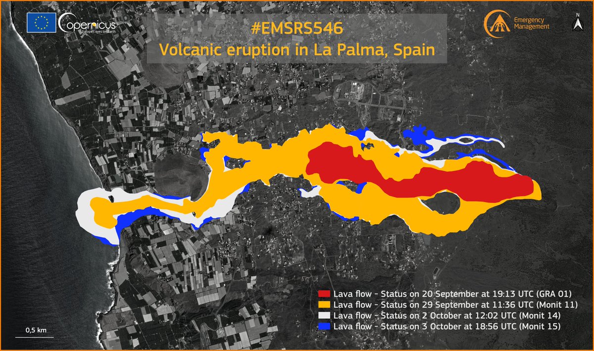
The latest progress of the lava flows as of the 3rd October. They are largely confined to the same areas, except for small breakouts and thickening. Image credit: Copernicus EMS
Sources: Government of the Canary Islands, PEVOLCA, Involcan, IGN, DSN, Cabildo La Palma, 112 Canarias, Tolouse VAAC, Copernicus EMS
Lava flows

Earthquakes

Exclusion zone map
Exclusion zones shown here have been approximated from press releases from the Cabildo de La Palma and will not be exact, nor claim to be official maps of the exclusion zones. For official information, please contact the Cabildo de La Palma.

Official social media
To see our full social media archive, visit our open data section or click here.
News articles
- Reuters – Awestruck volcano hunter left shaking by La Palma eruption – here
- El País – Volcanic eruption in La Palma: part of cone collapse – here
- Washington Post – Satellite captures La Palma volcano creating strange clouds – here
To see our full news archive, visit our open data section or click here.
Found a broken web link? We have archived all of our news articles on the WayBack Machine. You can view the pages by 1. pasting the broken link into WayBack Machine and clicking ‘Browse History’ 2. clicking on the latest capture date and then 3. clicking ‘view capture’. Please let us know of any broken web links by contacting us at enquiries@geotenerife.com.
Eruption footage
News and Interviews
Witness Testimonies
Interactive Lava Flow Map
Notes: Use the button in the top right to open the map into full screen mode. Use the legend icon in the top left to see the legend and further information about the map. Click on individual days to see an outline of the lava flows on that day.
Interactive Earthquake Map
click here to enlarge
Notes: The size of the points represents the size of the earthquake, and the colour represents the depth. The map will also only show a certain number of points at once. For ease of use, we recommend you uncheck all dates and the satellite basemap from the legend in the top right, and inspect the earthquakes one day at a time.
Sorry, the comment form is closed at this time.