16 Sep La Palma update 16th September 2021: Seismicity continues
La Palma update 16th september 2021: Seismicity continues
Daily summary
Miguel Ángel Morcuende, head of the Environment and Emergencies service of the Government of La Palma, has been appointed technical director of PEVOLCA and will be responsible for directing and coordinating all actions carried out under the Plan itself. To meet the telecommunications demands that an emergency could bring, the government has decided to upgrade the existing Canary Islands Emergency and Security Network (RESCAN).
Regarding the seismic swarm, the earthquakes have decreased slightly in both number and magnitude, although it is stressed that the intensification of activity in the short term cannot be ruled out. The average depth of the seismicity as further decreased however, being recorded largely at 4-5 km, however low magnitude shallow seismicity (1-3 km depth) also continues to be recorded. Across the island, inflation continues to be recorded, with up to 10 cm of vertical movement recorded, coincident with the location of the majority of the seismicity.
Sources: Government of the Canary Islands, PEVOLCA, Involcan, IGN, DSN, Cabildo La Palma, 112 Canarias
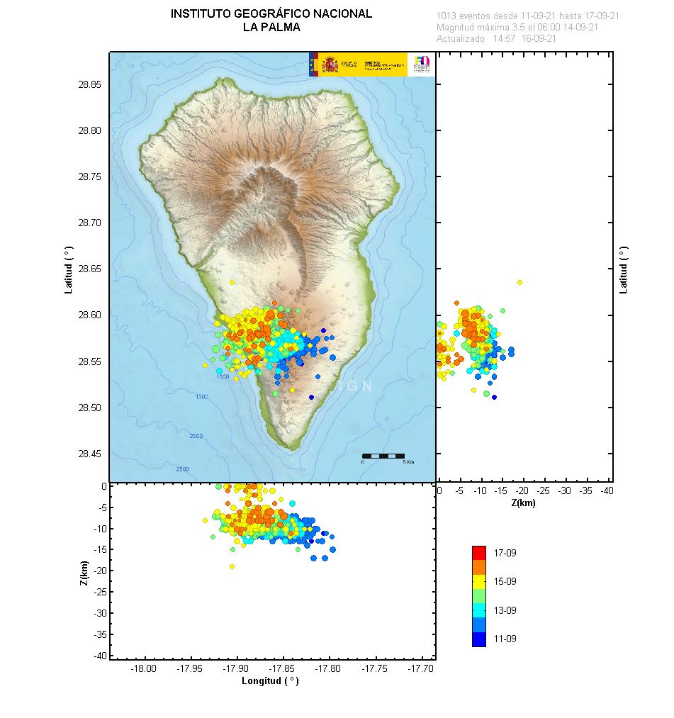
A map of the location and magnitude of the earthquakes since the start of the seismic swarm on the 11th. Image credit: IGN
Earthquakes

Official social media
To see our full social media archive, visit our open data section or click here.
News articles
- Daily Mail – Mail article that mentions the mega-tsunami and misrepresents interviewee – here
- Reuters – Earthquake swarm – here
To see our full news archive, visit our open data section or click here.
Found a broken web link? We have archived all of our news articles on the WayBack Machine. You can view the pages by 1. pasting the broken link into WayBack Machine and clicking ‘Browse History’ 2. clicking on the latest capture date and then 3. clicking ‘view capture’. Please let us know of any broken web links by contacting us at enquiries@geotenerife.com.
News and Interviews
Witness Testimonies
Interactive Lava Flow Map
Notes: Use the button in the top right to open the map into full screen mode. Use the legend icon in the top left to see the legend and further information about the map. Click on individual days to see an outline of the lava flows on that day.
Interactive Earthquake Map
click here to enlarge
Notes: The size of the points represents the size of the earthquake, and the colour represents the depth. The map will also only show a certain number of points at once. For ease of use, we recommend you uncheck all dates and the satellite basemap from the legend in the top right, and inspect the earthquakes one day at a time.
Sorry, the comment form is closed at this time.