22 Sep La Palma eruption update 22nd september 2021: Lava covers 140 hectares
La Palma eruption update 22nd september 2021: Lava covers 140 hectares
Daily summary
Due to cooling and the infilling of topographic lows, the lava flow fronts have slowed significantly, and now advance at around 4 metres per hour. The total area affected by the lava flow stands at 140 hectares, with the flow fronts measuring 600 metres across. The episode of increased explosiveness that began at 7pm local time on the 21st ended at 2am local time and coincided with a small collapse of a portion of the cone. Strombolian activity continues producing both ash and lava flows from multiple vents in the vicinity of a principal cone that has formed around the most active vents. In the current state, up to 9 vents along one fissure have been observed by the authorities, although on average only 4 of these are active at any one time. This activity is emitting over 12,000 tons of SO2 per day up to 3000 m, although the amount of SO2 released per day is thought to be an underestimate according to PEVOLCA, as such ground-based measurements cannot be used to observe the full extent of the plume, unlike satellite observations.
Concerning geophysical parameters, the volcanic tremor has seen a decrease in amplitude attributed to the concentration of the activity around a smaller area, compared to the first hours of the eruption. Deformation for the moment seems to have stabilised, and the maximum measured inflation since the start of the seismic swarm remains the 28cm measured by InSAR (Interferometric Synthetic-Aperture Radar). Earthquake activity remains at a low level, with 7 earthquakes recorded, peaking at 3.0 mbLg.
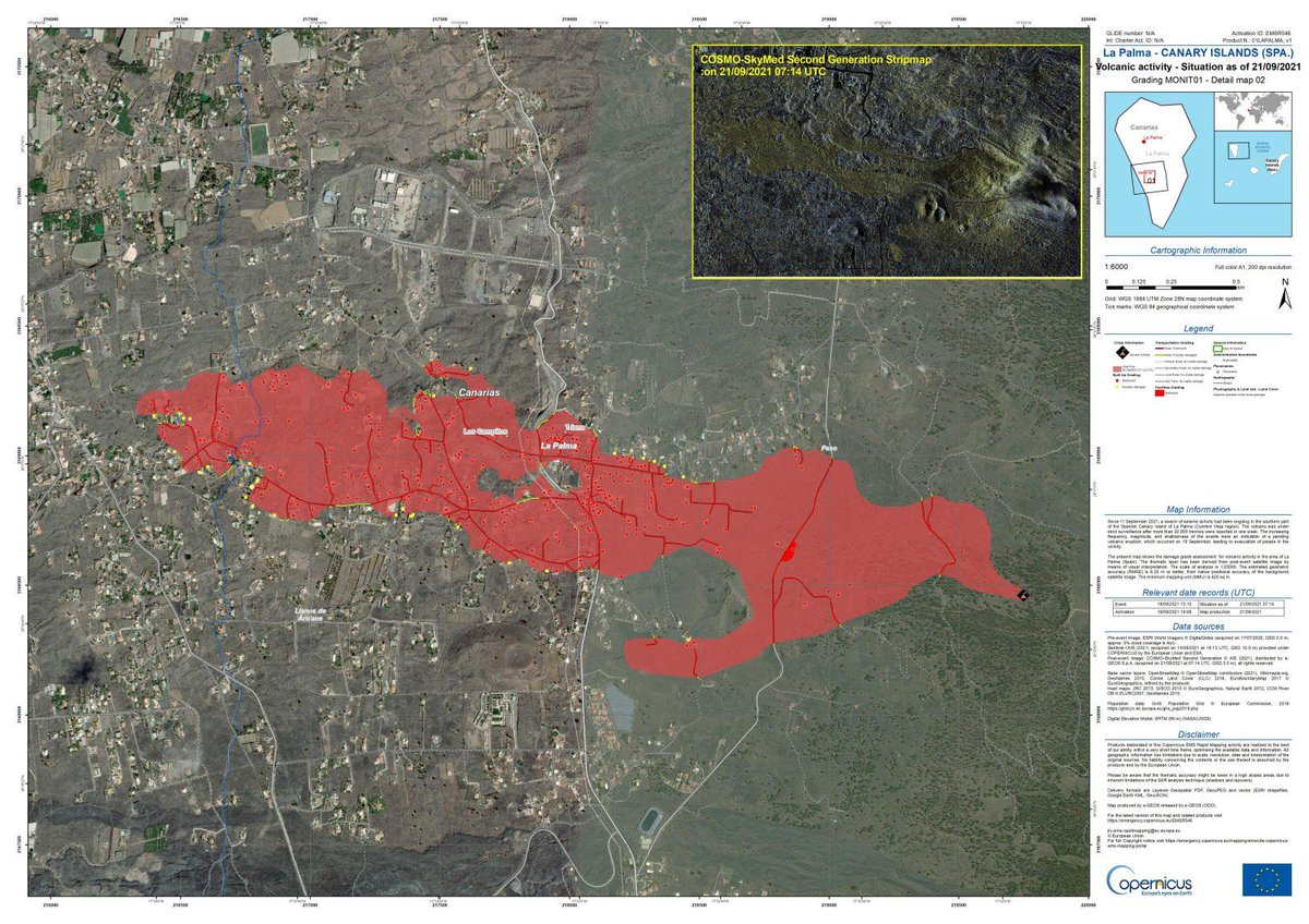
The latest maps of the lava flows (accurate as of the 21st September) showing the roads and buildings destroyed (red dots) and damaged (yellow dots). Image credit: Copernicus EMS
Sources: Government of the Canary Islands, PEVOLCA, Involcan, IGN, DSN, Cabildo La Palma, 112 Canarias, Tolouse VAAC
Lava flows

Earthquakes

Exclusion zone map
Exclusion zones shown here have been approximated from press releases from the Cabildo de La Palma and will not be exact, nor claim to be official maps of the exclusion zones. For official information, please contact the Cabildo de La Palma.

Official social media
To see our full social media archive, visit our open data section or click here.
News articles
- Canary Islands Government – Purchase of first 73 homes for those affected by the eruption – here
- Reuters – Interview with victims of the eruption – here
- Independent – Volcano described as a “Wonderul Show” – here
To see our full news archive, visit our open data section or click here.
Found a broken web link? We have archived all of our news articles on the WayBack Machine. You can view the pages by 1. pasting the broken link into WayBack Machine and clicking ‘Browse History’ 2. clicking on the latest capture date and then 3. clicking ‘view capture’. Please let us know of any broken web links by contacting us at enquiries@geotenerife.com.
Eruption footage
News and Interviews
Witness Testimonies
Interactive Lava Flow Map
Notes: Use the button in the top right to open the map into full screen mode. Use the legend icon in the top left to see the legend and further information about the map. Click on individual days to see an outline of the lava flows on that day.
Interactive Earthquake Map
click here to enlarge
Notes: The size of the points represents the size of the earthquake, and the colour represents the depth. The map will also only show a certain number of points at once. For ease of use, we recommend you uncheck all dates and the satellite basemap from the legend in the top right, and inspect the earthquakes one day at a time.
Sorry, the comment form is closed at this time.