
The VolcanoStories project by GeoTenerife is a multi-media, science communication project, creating bespoke resources about volcanic activity, preparedness, reconstruction, and sustainable tourism in the Canary Islands. We collaborate with leading local, regional, and national institutions via our unique training programmes GeoIntern, VolcanoCamp, and MarineSciCamp for students and scholars from around the globe.
La Palma infrastructure reconstruction, struggles of the residents, and the eruption
Over-tourism protests, unsustainable resorts, and activist movements
Volcanic risk, emergency plans, communication, and preparedness in the Canary Islands.
New: Opinion Piece published on VolcanoStories
Short-form , easy-to-read, articles, which are relevant to the residents of the Canary Islands. Available en Español and in English.
El lado oscuro del turismo sostenible Cuna del Alma, Islas Canarias
“Cuna del Alma” es un hotel de lujo planeado para el Puertito de Adeje, en el sur de Tenerife, promocionado como un complejo turístico sostenible. Ha sido objeto de controversia desde que comenzaron las obras. Desde abril de 2024 se han producido protestas masivas contra este proyecto y el mode
The dark side of sustainable tourism: Cuna del Alma, Canary Islands
“Cuna del Alma” is a planned luxury hotel in Puertito de Adeje, in southern Tenerife, selling itself as a sustainable resort. It has been at the centre of controversy since construction began. Mass protests against this project and the economic model it represents have been ongoing since April 2
NEW: La Palma Reconstruction Update
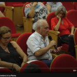
La Palma Reconstruction – March 2026
Demand for more transparency from INVOLCAN - La Palma hosts new international volcanology course - More aid for self-employed works - €1.24 billion from the state in total so far - Aid extension for farmers affected by the volcano - More than half of second home payments processed - Reconstruction
La Palma Reconstruction – February 2026
€1.3 million for security and emergencies - Participatory process for new Volcanic Risk Action Plan - New images show marine recovery - Spanish Government advances infrastructure funds - Debates over 60% income tax reduction and 25% financing from the Canary Islands Government - Extension for aid
Urgent events: 18M Protest
Frustrated by unchecked development and environmental degradation, 200,000 Canarians protested in April and several thousand again in October 2023, demanding a more sustainable tourism model that prioritises local needs and protects the islands’ fragile ecosystem. A third large-scale protest is being organised for May 2025 which we will be covering here on Urgent events.

El lado oscuro del turismo sostenible Cuna del Alma, Islas Canarias
“Cuna del Alma” es un hotel de lujo planeado para el Puertito de Adeje, en el sur de Tenerife, promocionado como un complejo turístico sostenible. Ha sido objeto de controversia desde que comenzaron las obras. Desde abril de 2024 se han producido protestas masivas contra este proyecto y el mode
NEW: El Puertito and the Cuna del Alma resort
Cuna del Alma, el Aula Marina, y las Tortugas
Las Islas Canarias se promocionan como un paraíso de biodiversidad y turismo sostenible. Pero la historia del Puertito de Adeje SeaLab revela una realidad muy distinta: un patrón en el que las autoridades locales explotan las iniciativas de restauración ambiental para generar relaciones públicas
Cuna del Alma, the SeaLab and the Turtles
The Canary Islands are marketing themselves as a paradise of biodiversity and sustainable tourism. But the story of the Puertito de Adeje SeaLab reveals a very different truth: a pattern in which local authorities exploit environmental restoration initiatives for public relations, only to erase them
Have a comment or want to ask us a question? Our forum is a space for questions, reflections and comments.
Forum for VolcanoStories questions
Forum Navigation
VolcanoStories Forum
VolcanoStoriesLast post
Q+A about Sustainable TourismAsk the Researchers, Editors, and Collaborating experts of VolcanoStories Sustainable Tourism project about our work in the Canary Islands0 Topics · 0 PostsNo topics yet!
No topics yet!
Q+A about Volcanic ReadinessAsk the Researchers, Editors, and Collaborating experts of VolcanoStories Volcanic Readiness project about our work in the Canary Islands1 Topic · 2 PostsLast post: Resiliencia volcánica · 7 months ago · GeoTenerife
Q+A about La Palma's reconstructionAsk the Researchers, Editors, and Collaborating experts of VolcanoStories La Palma project about our work in La Palma post eruption.2 Topics · 4 PostsLast post: ¿Por qué la información solo se pu … · 9 months ago · GeoTenerife
LAVA BOMBS SeriesA space for any questions, discussion, and debate regarding the themes of the two LAVA BOMBS series.0 Topics · 0 PostsNo topics yet!
No topics yet!
Any other questions ?This is a space for any other questions you have about GeoTenerife's work0 Topics · 0 PostsNo topics yet!
No topics yet!
Q+A about volcanic unrestQuestions about current or previous volcanic unrest in the Canary Islands6 Topics · 12 PostsLast post: Are IGN, Involcán and the Presiden … · 9 months ago · GeoTenerife
La ConversaciónUn espacio para que los residentes comenten o hagan preguntas sobre nuestros artículos de opinión.6 Topics · 6 PostsLast post: La conversación: El lado oscuro de … · 1 month ago · GeoTenerife
The ConversationA space for residents to comment, ask questions, and engage with the subject of about our opinion pieces7 Topics · 7 PostsLast post: The Conversation: The dark side of … · 1 month ago · GeoTenerife
Statistics
25
Topics
34
Posts
27,019
Views
166
Users
Published articles and Opinion pieces
Our published work, posters and presentations at conferences can be accessed below through GeoTenerife’s VolcanoStories ResearchGate:
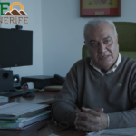
THE COMMUNICATION AND INFORMATION PROCESS DURING THE LA PALMA ERUPTION ERRORS, SUCCESSES, LEARNINGS AND PROPOSALS FOR IMPROVEMENT
After nearly fifty years without showing obvious signs of volcanic activity on the surface, in 2021 there was a new eruption in the area known as Cabeza de Vaca in La Palma (Canary Islands, Spain). The eruption lasted eighty-five days and caused numerous losses due to the extensive area affected by
We aim to use our project to publish short-form articles, which are easy to read, and relevant to residents, especially La Palma’s reconstruction, volcanic readiness, and tourism practices in the Canary Islands. Available en Español and in English.
El lado oscuro del turismo sostenible Cuna del Alma, Islas Canarias
“Cuna del Alma” es un hotel de lujo planeado para el Puertito de Adeje, en el sur de Tenerife, promocionado como un complejo turístico sostenible. Ha sido objeto de controversia desde que comenzaron las obras. Desde abril de 2024 se han producido protestas masivas contra este proyecto y el mode
Lava Bombs Project
")
Lava Bombs: Truths Behind The Volcano captures the explosive stories behind the crisis and response to the 2021 Volcán de Tajogaite eruption in Cumbre Vieja on La Palma in the Canary Islands. Lava Bombs reveals the heavy impact of this major disaster, through the voices of the affected people, emergency managers, politicians and scientists, as well as showcasing spectacular imagery captured by witnesses, news crews and drone pilots. Themes of communication, trust and missteps are analysed as we start to look towards lessons learned for future emergencies of all kinds

Lava Bombs: The Reconstruction dives into what happens after the most destructive eruption in an island’s history ends. The eruption of the Tajogaite volcano hit international headlines in 2021, but LavaBombs Part 2 reveals the struggle to recover on this small island in the middle of the Atlantic. Through dramatic footage and intimate testimony from politicians, scientists, residents and activists this new documentary digs deep behind the headlines to unpick the successes and failures of the following two years post-eruption.
Urgent Events in the Canary Islands
We aim to collect and publish updates, from trustworthy news sources, regarding urgent events in the Canary Islands, so that residents and tourists alike can use this hub of information during an emergency and act as a record of events after the event has ended.
Demonstrations against unsustainable tourism
• Summarising key events in a simple timeline • Database of news coverage and social media responses • Resources on why the foundations are organising demonstrations • GeoTenerife's press releases and comments to the international media
Tens of thousands of Canarian residents protested on the 20th of April and October to make their concerns heard about unsustainable tourism; They want a new tourism model implemented that incorporates their concerns and protects their biodiverse paradise in the Atlantic. GeoTenerife compiles news resources and social media on this developing story below so that locals, students, researchers and journalists alike can access it openly.

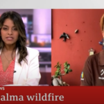
Tenerife’s 2023 wildfire was the most devastating fire in the Canary Islands in the last 40 years and the most severe in Spain in 2023; The fire affected nearly 15,000 hectares, burning 7% of the surface of Tenerife, and causing 80.4 million euros of damage. The forest fire has caused approximately 12 million euros of damage to the agricultural sector, including 2,500-3,500 hives that were destroyed. In addition, it caused more than 12,000 people to have to be evacuated throughout the course of the fire, 364 farms and 246 buildings were affected. Up to 60 protected species may have been impacted by the forest fire, but the true impact on these species is not yet known.
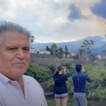
The volcanic eruption on La Palma was preceded by a seismic swarm starting on September 11th, and by September 19th the volcano, later named Tajogaite, started erupting. Over the following weeks and months, the lava flows continued to advance, encroaching over 900 hectares of land and destroying more than 1,000 buildings. The eruption was accompanied by earthquakes with magnitudes up to 5.1 mbLg, occasionally felt across multiple Canary Islands.
Our Day-by-Day Eruption Updates from September 11th 2021 – December 25th 2021 includes:
- Maps of lava flows, earthquakes, and exclusion zones each day
- Summary of geological data released by IGN
- Twitter posts made by official Canarian civil service accounts and scientists

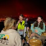
Outreach
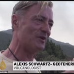
Interviews
We are often interviewed by local, national, and international news sources for information about volcanic activity, forest fires, and more in the Canary Islands. We are happy to share our knowledge with as many people as possible.
Resident focus
Alongside our resident-focused science, we run the campaigns FFP2 and SamuLaPalma to support those affected by the La Palma 2021 eruption. Furthermore, we make school visits to encourage volcano science in younger Canarian Residents, and also make our internship programmes accessible to students who live in the Canary Islands to ensure our projects benefit the residents of the Canary Islands.
Conferences
We co-organise the annual VulcanaSymposium with the IEO and also attend other volcanological conferences, VMSG, IAVCEI, and COV12, to discuss our projects and their results with experts in the field of volcano science, in particular Q&As for our LavaBombs documentary. Our VolcanoStories Content Co-ordinator was invited to present at the Royal Holloway University Lyell Geology Day regarding the Tajogaite Eruption timeline project.

Collaborations
GeoTenerife is committed to fostering valuable collaborations with local, national, and international research institutions, to both conduct valuable geoscience research in the Canary Islands
We are always looking to welcome new collaborations, so if you or your company/research institution is interested in collaborating with us, please get in touch with us via enquiries@geotenerife.com
Our Collaborators include:
- IGN, Instituto Geográfico Nacional
- Dr Catalina Arguello, Social Psychologist, Universidad Internacional de La Rioja
- Dr Katy Chamberlain, Volcanologist, Liverpool University
- Dr Pablo Gonzalez, Volcano Geophysicist, Spanish National Research Council
and many more valued collaborators.


