21 Nov La Palma eruption update 21st November 2021: The active lava flows are concentrated to the north of the lava flow field
La Palma eruption – 21st November 2021
Daily summary
The contribution of lava to the active lava flows has been concentrated around flows 4 and 7 which both flow parallel in between La Laguna Mountain and Todoque Mountain, and in the last 24 hours have merged a few hundred metres from the coast, to the SW of La Laguna Mountain. The flows are currently affecting new land which consists largely of banana plantations. Smaller contributions of active lava also feed flows 1, 2 and 9 which feed the lava delta. The latest data on damage from Copernicus shows that 2,731 buildings have been damaged or destroyed by the lava flows, although the local land registry only calculated 1,467 buildings to have been affected so far. The rate of seismicity remained low-medium. 50 events were recorded, with a higher proportion of intermediate (10-15 km depth) events to deep (30-45 km depth) events, although the day’s largest earthquake was a mbLg 4.3 event at 36 km depth.
Volcanic tremor remains low with some occasional fluctuation, whilst the local 6 cm inflation observed at the LP03 GPS station in Jedey closest to the eruption continues to reverse. A small weakening regional deflation signal remains seen in the other stations. SO2 emissions decreased markedly compared to previous days, at 900-1,300 tons per day, whilst the ash and gas plume was measured at 2,000 m. As a general trend, satellite measurements imply current SO2 emissions are lower than the start of the eruption. Air quality with respect to SO2 decreased in the early hours, reaching extremely unfavourable levels and exceeding the alert threshold (500 μg/m3) in Los Llanos and El Paso, although these recovered to good levels throughout the day. Good SO2 levels were reported in all other stations throughout the day. PM10 levels were good in the west of the island, although due to the current wind direction PM10 levels were worse on the eastern side of the island, with the El Pilar and La Grama stations reached unfavourable levels and exceeded the daily limit threshold (50 μg/m3).
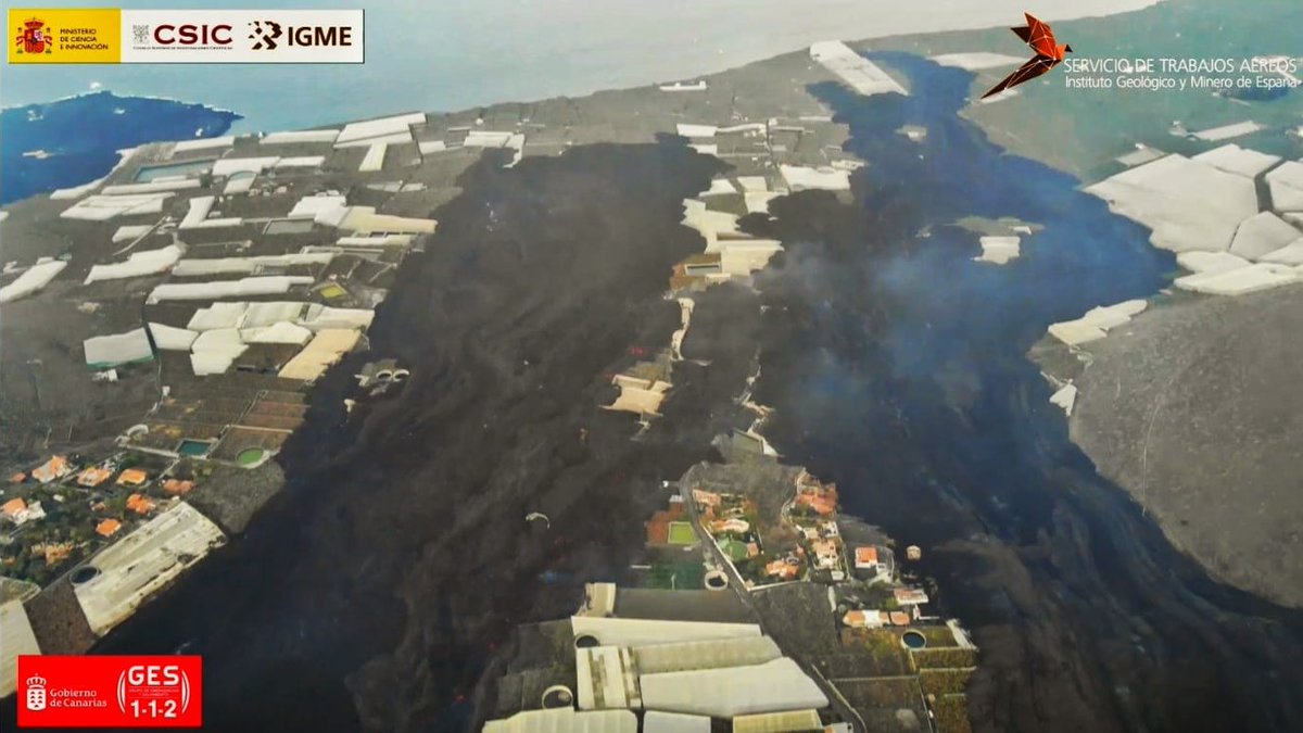
The active lava flows on the 21st which have merged near the coast to the west of La Laguna Mountain. Image credit: 112 Canarias, CSIC, IGME
Sources: Government of the Canary Islands, PEVOLCA, Involcan, IGN, DSN, Cabildo La Palma, 112 Canarias, Tolouse VAAC, Copernicus EMS
Lava flows

Earthquakes

Exclusion zone map
Exclusion zones shown here have been approximated from press releases from the Cabildo de La Palma and will not be exact, nor claim to be official maps of the exclusion zones. For official information, please contact the Cabildo de La Palma.

Official social media
To see our full social media archive, visit our open data section or click here.
News articles
- Euractiv -Spain eyes EU solidarity fund – here
- El Mundo – Carmen Lopez interview – here
- RTVE – Eruption latest updates – here
To see our full news archive, visit our open data section or click here.
Found a broken web link? We have archived all of our news articles on the WayBack Machine. You can view the pages by 1. pasting the broken link into WayBack Machine and clicking ‘Browse History’ 2. clicking on the latest capture date and then 3. clicking ‘view capture’. Please let us know of any broken web links by contacting us at enquiries@geotenerife.com.
Eruption footage
News and Interviews
Witness Testimonies
Interactive Lava Flow Map
Notes: Use the button in the top right to open the map into full screen mode. Use the legend icon in the top left to see the legend and further information about the map. Click on individual days to see an outline of the lava flows on that day.
Interactive Earthquake Map
click here to enlarge
Notes: The size of the points represents the size of the earthquake, and the colour represents the depth. The map will also only show a certain number of points at once. For ease of use, we recommend you uncheck all dates and the satellite basemap from the legend in the top right, and inspect the earthquakes one day at a time.
Sorry, the comment form is closed at this time.