20 Nov La Palma eruption update 20th November 2021: The eruption is now a VEI 3 based upon the amount of material emitted
La Palma eruption – 20th November 2021
Daily summary
The cumulative amount of material expelled by the eruption so far is thought to have reached the threshold value (10 million m3) for the classification of the eruption to change from a Volcanic Explosivity Index (VEI) 2 eruption to a VEI 3 eruption. However, PEVOLCA were keen to explain that this value only represents the amount of material emitted by the eruption and does not imply any changes to the eruption dynamics. Elsewhere, changes in the wind direction and ash dispersal have caused the closure of La Palma airport, with flights being cancelled. The three active lava flow fronts from the 19th remain, with the flow between La Laguna Mountain and Todoque Mountain advancing 130 m across new farmland. The rate of seismicity remained low-medium. 77 events were recorded, with similar amounts at both intermediate (10-15 km) and deep (30-45 km) depths, with the day’s largest earthquake being a mbLg 4.6 event at 37 km depth.
Volcanic tremor remains low, whilst the local inflation observed at the LP03 GPS station in Jedey closest to the eruption increased from 4 cm to 6 cm, although it is beginning to show a partial reversal. A small weakening regional deflation signal remains seen in the other stations. SO2 emissions were similar to the 19th at 7,000-18,000 tons per day, whilst the ash and gas plume was measured at 3,200 m. However, satellite measurements imply current SO2 emissions are lower than the start of the eruption. Air quality decreased in the early hours; SO2 values exceeded the hourly limit threshold (350 μg/m3) twice in Tazacorte and increased generally in all stations, although all stations returned to good levels throughout the day. PM10 levels remained low in all stations again, with none exceeding the daily limit threshold (50 μg/m3).
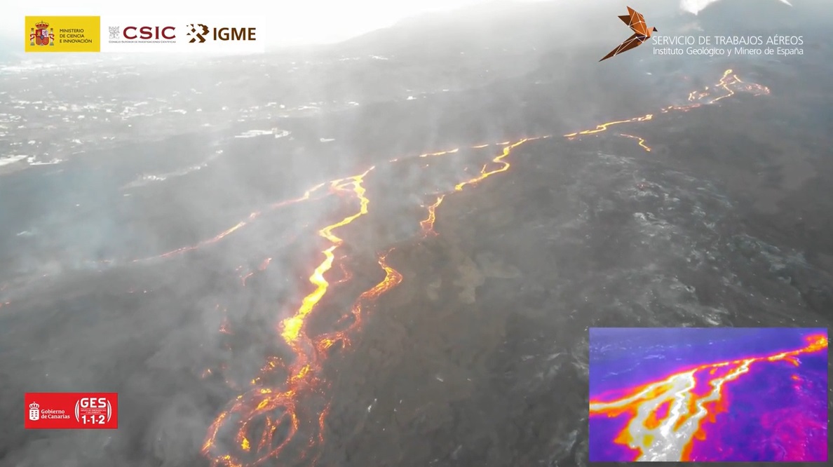
A drone image from the 20th looking east from near La Laguna upstream the active lava flows towards the eruptive cone in the top right of the image. In the inset thermal image the active lava flows can be clearly distinguished. Image credit: IGN, CSIC
Sources: Government of the Canary Islands, PEVOLCA, Involcan, IGN, DSN, Cabildo La Palma, 112 Canarias, Tolouse VAAC, Copernicus EMS
Lava flows

Earthquakes

Exclusion zone map
Exclusion zones shown here have been approximated from press releases from the Cabildo de La Palma and will not be exact, nor claim to be official maps of the exclusion zones. For official information, please contact the Cabildo de La Palma.

Official social media
To see our full social media archive, visit our open data section or click here.
News articles
- La Liga Newsletter – All LaLiga clubs join forces to help La Palma – here
- El Mundo – La Palma volcano – latest, live – here
To see our full news archive, visit our open data section or click here.
Found a broken web link? We have archived all of our news articles on the WayBack Machine. You can view the pages by 1. pasting the broken link into WayBack Machine and clicking ‘Browse History’ 2. clicking on the latest capture date and then 3. clicking ‘view capture’. Please let us know of any broken web links by contacting us at enquiries@geotenerife.com.
Eruption footage
News and Interviews
Witness Testimonies
Interactive Lava Flow Map
Notes: Use the button in the top right to open the map into full screen mode. Use the legend icon in the top left to see the legend and further information about the map. Click on individual days to see an outline of the lava flows on that day.
Interactive Earthquake Map
click here to enlarge
Notes: The size of the points represents the size of the earthquake, and the colour represents the depth. The map will also only show a certain number of points at once. For ease of use, we recommend you uncheck all dates and the satellite basemap from the legend in the top right, and inspect the earthquakes one day at a time.
Sorry, the comment form is closed at this time.