06 Oct La Palma eruption update 6th october 2021: The eruption remains relatively stable
La Palma eruption update 6th october 2021: The eruption remains relatively stable
Daily summary
A relatively stable period in the eruption continues, both in respect to the paths taken by the lava flows and the surface eruptive activity. The lava flows continue to feed the lava delta via lava tubes, and the eruption continues to show a strombolian behaviour from multiple active vents in the main cone that vary in intensity, as well as more effusive activity from two vents on the flanks of the main cone. There was a small breakout lava flow flowing towards the north of Todoque mountain, although for now these flows have become inactive. For the first time since the eruption began, damage statistics for agriculture have been published; 93.4 hectares have been affected by the lava flows so far, including 35.6 hectares of bananas and 32.9 hectares of vineyards.
The meteorological conditions are expected to become more unfavourable with respect to air quality in the coming days, as the height of the thermal inversion is expected to decrease. Regarding deformation, relative stability is seen throughout the network. Earthquake activity continues to be concentrated at 10-15 km depth in the area of the precursory swarms, although at lower levels than observed on the 4th October. 57 earthquakes were recorded, peaking at 3.9 mbLg. The ash plume height was 3000 m, although no data was published regarding the SO2 emissions in the plume, although given the stability in activity it is expected to be similar to the values registered on the 5th October.
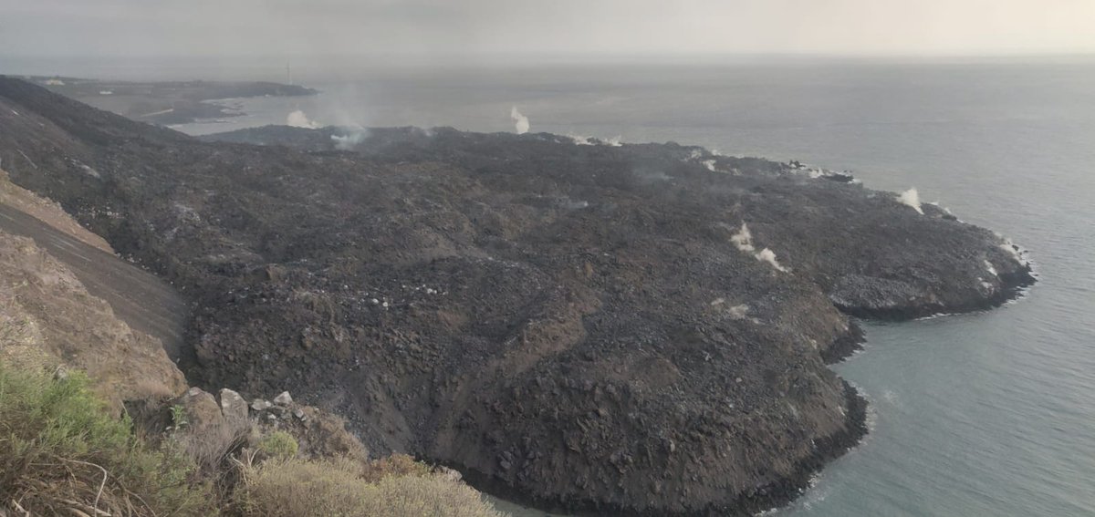
A view of the lava delta which is expanding as it continues to be fed by lava tubes. Image credit: IGN Spain
Sources: Government of the Canary Islands, PEVOLCA, Involcan, IGN, DSN, Cabildo La Palma, 112 Canarias, Tolouse VAAC, Copernicus EMS
Lava flows

Earthquakes

Exclusion zone map
Exclusion zones shown here have been approximated from press releases from the Cabildo de La Palma and will not be exact, nor claim to be official maps of the exclusion zones. For official information, please contact the Cabildo de La Palma.

Official social media
To see our full social media archive, visit our open data section or click here.
News articles
- Kiratas – Contains links to the INVOLCAN close call from the volcano – here
- Sky News – Tui cancels flights to La Palma – here
- El País – The underwater ‘hotspot’ feeding La Palma’s volcano will create new islands – here
To see our full news archive, visit our open data section or click here.
Found a broken web link? We have archived all of our news articles on the WayBack Machine. You can view the pages by 1. pasting the broken link into WayBack Machine and clicking ‘Browse History’ 2. clicking on the latest capture date and then 3. clicking ‘view capture’. Please let us know of any broken web links by contacting us at enquiries@geotenerife.com.
Eruption footage
News and Interviews
Witness Testimonies
Interactive Lava Flow Map
Notes: Use the button in the top right to open the map into full screen mode. Use the legend icon in the top left to see the legend and further information about the map. Click on individual days to see an outline of the lava flows on that day.
Interactive Earthquake Map
click here to enlarge
Notes: The size of the points represents the size of the earthquake, and the colour represents the depth. The map will also only show a certain number of points at once. For ease of use, we recommend you uncheck all dates and the satellite basemap from the legend in the top right, and inspect the earthquakes one day at a time.
Sorry, the comment form is closed at this time.