15 Sep La Palma update 15th September 2021: Seismic swarm continues
La Palma update 15th september 2021: Seismic swarm continues
Daily summary
As the seismic swarm continues to intensify, PEVOLCA maintains the yellow traffic light in the municipalities of El Paso, Los Llanos de Aridane, Mazo and Fuencaliente, although comments that there is still no evidence of an imminent eruption. Over the last couple of days, the seismicity has become displaced to the northwest relative to the focus at the beginning of the swarm, and the average depth has decreased and is now between 6-8 km. Additionally, today some lower magnitude earthquakes have been detected much nearer the surface (1-3 km).
The earthquake activity is now being accompanied by surface deformation recorded by GPS stations across La Palma. A maximum of 6 cm of vertical inflation has been recorded so far, coincident with the location of greatest seismicity. However, a point is made that gradual increases in seismic activity prior to a volcanic eruption can last for a long time, so the population should not panic. Nonetheless, following the civil protection advice afforded by the yellow traffic light, it is recommended to pack a small travel bag in the case of an evacuation with essential documents and other belongings, have a place to stay outside the at-risk areas, and to notify the local authorities if you would require mobility assistance in the event of an eruption.
Sources: Government of the Canary Islands, PEVOLCA, Involcan, IGN, DSN, Cabildo La Palma, 112 Canarias
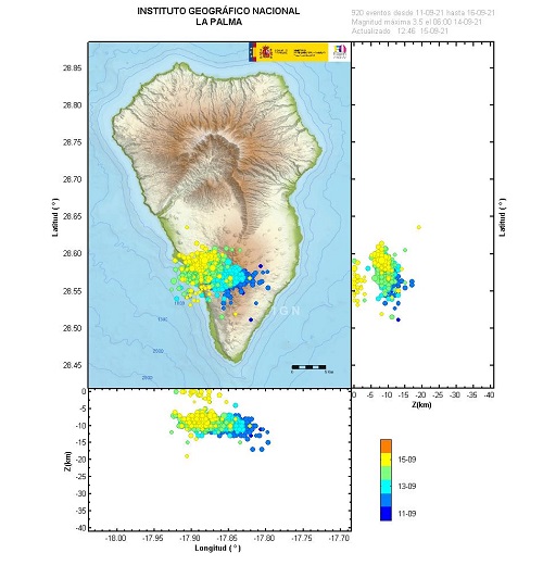
The time, location and magnitude of earthquakes recorded by IGN since the beginning of the seismic swarm on the 11th September. Image credit: IGN
Earthquakes

Official social media
To see our full social media archive, visit our open data section or click here.
News articles
To see our full news archive, visit our open data section or click here.
Found a broken web link? We have archived all of our news articles on the WayBack Machine. You can view the pages by 1. pasting the broken link into WayBack Machine and clicking ‘Browse History’ 2. clicking on the latest capture date and then 3. clicking ‘view capture’. Please let us know of any broken web links by contacting us at enquiries@geotenerife.com.
News and Interviews
Witness Testimonies
Interactive Lava Flow Map
Notes: Use the button in the top right to open the map into full screen mode. Use the legend icon in the top left to see the legend and further information about the map. Click on individual days to see an outline of the lava flows on that day.
Interactive Earthquake Map
click here to enlarge
Notes: The size of the points represents the size of the earthquake, and the colour represents the depth. The map will also only show a certain number of points at once. For ease of use, we recommend you uncheck all dates and the satellite basemap from the legend in the top right, and inspect the earthquakes one day at a time.
Sorry, the comment form is closed at this time.