08 Oct La Palma eruption update 8th october 2021: Airport operations affected by ash
La Palma eruption update 8th october 2021: Airport operations affected by ash
Daily summary
The breakout lava flow that emerged on the 7th near the coast has covered over 40 hectares of new land, mostly destroying banana plantations, so the total affected area is now 471 hectares. The eruptive activity remains stable, with at least 3 strombolian vents in the main cone and now only a single vent on the flanks of the main cone, on the northern sector. The weather conditions remained unfavourable from an air quality perspective and also for ash deposition. Both La Palma airport and Tenerife North airport had operations affected by the accumulation of ash throughout the day, and it is not ruled out that La Gomera and Tenerife south airport could also be affected by ashfall. From tomorrow, however, meteorological conditions should allow being favourable for air quality and ash dispersion. A peak in SO2 concentrations was recorded in El Paso and Los Llanos between 6:00 and 8:00 am local time, although the hourly thresholds were not exceeded in either of the stations throughout the day. The daily threshold for PM10 concentrations was slightly exceeded in Los Llanos, but stayed below the threshold in all other stations.
For other eruption parameters, volcanic tremor is average and quite stable, with very infrequent peaks in amplitude. Deformation remains stable, with no significant trends being seen in the stations close to the eruption site. Earthquake activity remained relatively high and concentrated in the same areas at 10-15 km depth, although there have been some deep (20-40 km) earthquakes reported as well. 60 events were recorded, peaking at 4.2 mbLg. The ash and gas plume reached, 3500 m, and the SO2 emissions from the volcano were 6,876 tons per day. For the first time, estimates of the HCl emissions from the volcano were available. These data, relating to October 6th, estimated 497 tons per day in the volcanic plume, and 43 tons per day from the marine plume from the lava delta.
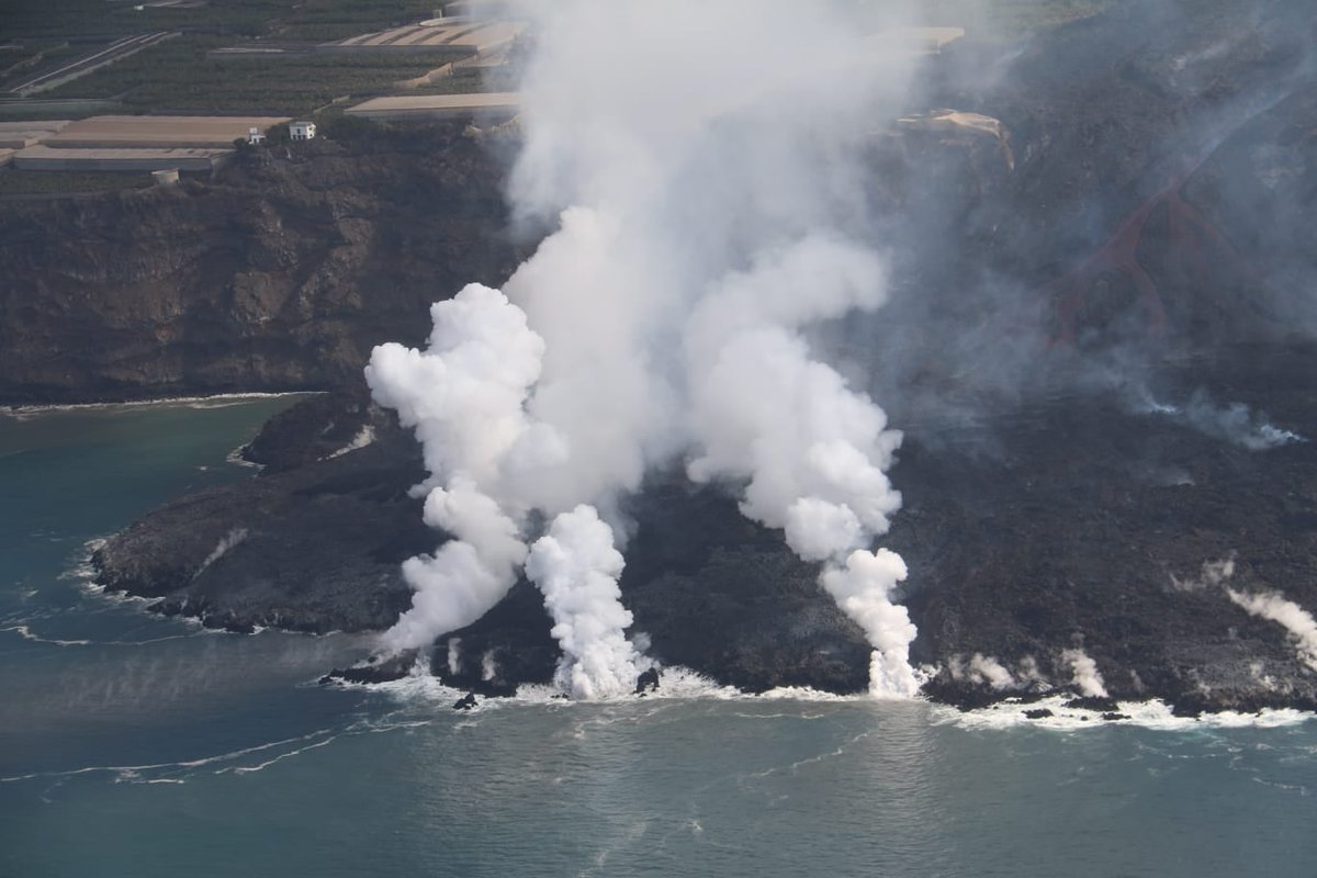
The lava delta on the 8th October as seen from the air, where the feeding flows as well as generation of large clouds of steam can be seen. Image credit: INVOLCAN
Sources: Government of the Canary Islands, PEVOLCA, Involcan, IGN, DSN, Cabildo La Palma, 112 Canarias, Tolouse VAAC, Copernicus EMS
Lava flows

Earthquakes

Exclusion zone map
Exclusion zones shown here have been approximated from press releases from the Cabildo de La Palma and will not be exact, nor claim to be official maps of the exclusion zones. For official information, please contact the Cabildo de La Palma.

Official social media
To see our full social media archive, visit our open data section or click here.
News articles
- El País – The expedition to the center of La Palma volcano: “A vent opened up beneath our feet” – here
- AS USA – 7th october 2021 Eruption summary – here
To see our full news archive, visit our open data section or click here.
Found a broken web link? We have archived all of our news articles on the WayBack Machine. You can view the pages by 1. pasting the broken link into WayBack Machine and clicking ‘Browse History’ 2. clicking on the latest capture date and then 3. clicking ‘view capture’. Please let us know of any broken web links by contacting us at enquiries@geotenerife.com.
Eruption footage
News and Interviews
Witness Testimonies
Interactive Lava Flow Map
Notes: Use the button in the top right to open the map into full screen mode. Use the legend icon in the top left to see the legend and further information about the map. Click on individual days to see an outline of the lava flows on that day.
Interactive Earthquake Map
click here to enlarge
Notes: The size of the points represents the size of the earthquake, and the colour represents the depth. The map will also only show a certain number of points at once. For ease of use, we recommend you uncheck all dates and the satellite basemap from the legend in the top right, and inspect the earthquakes one day at a time.
Sorry, the comment form is closed at this time.